Sunday, May 14, 2017

Green STOP Signs coming to Ogletown

The above is but one concept being planned for a STOP
campaign yard sign. Make plans to join in the effort today!
Advocates at Save the Orphanage Property are moving ahead with "STOP" signs. Bumper stickers may follow. Countless residents are eagerly waiting for something that they can place in their yard or at curbside, to bring the campaign that much closer to the region. With deafening silence from our Legislators and Councilwoman Diller concerning the property's fate, the organization has no choice but to raise the stakes. Despite Executive Meyer's unswerving "commitment" (made at the last NCC Civic League Meeting) to making the park a reality, planning for the Chestnut Hill "Preserve" is all but wrapped up according to the project's page on the NCC Dept of Land Use (DLU) website.

Nobody understands the political implications of the effort more than STOP advocates, yet the distrust on the part of our leaders -- usually on display at meetings and with poor decorum in general -- persists. If we were approached in confidence that indeed, a parkland deal was coming together, and that its success hinged upon a pullback of STOP campaign activities, we would go eerily silent until the wonderful news broke. Instead, for reasons we have yet to grasp, advocates are viewed as carrying bullhorns, ready to mouth off at every opportunity.

Stay tuned in the coming few weeks for more about STOP's new campaign signs, including pickup or delivery information. Followers will also be given the opportunity to donate the wholesale cost of the sign, which is expected to fall well under $5/piece. Said donation will not be mandatory, of course, as the goal is to distribute the signs far and wide.

A yard sign for open space funding via referendum. Unlike other States, DE does not permit referendums at the voting booth. Such a lesser form of democracy leaves citizens with little choice but to advocate for existing government funds, or to hope for benefactor(s).

Saturday, May 13, 2017

Advocacy opportunities in the coming weeks

Civic League of NCC Annual Meeting 
All are welcome. Keynote speaker will be Jennifer Cohan, DelDOT Secretary of Transportation. This is an excellent opportunity to raise bike-ped infrastructure safety issues and concerns.  Date: Tuesday May 16. Time:  7:00 - 9:00 p.m. Location: Christiana Presbyterian Church, 15 North Old Baltimore Pike, Christiana, DE 19702.

Glasgow Avenue Main Street Study
WILMAPCO, DelDOT, and New Castle County have kicked off a year-long transportation and land use study for Glasgow Avenue, between US 40 and SR 896/Porter Road (about 1.3 miles).  The study is intended to create a “Main Street” vision plan to guide transportation improvements and land use along Glasgow Avenue. You are invited to this final community workshop. During the meeting, project partners will share the study recommendations and collect your input. Date: Monday, May 22. Time: from 4:30 to 7 p.m. Location: Hodgson Vo-tech High School Cafeteria.

Blueprint for a Bicycle-Friendly Delaware
The State and other organizations are working on a bicycle policy plan to support the development of a safe, connected, and equitable network of bicycle facilities throughout the state! Your input will help planners better understand where people want to bike and problematic locations and corridors for people trying to bike. It's easy; simply input a valid email address, and start marking your trouble points and recommended routes. You can also comment on what others have already submitted.


Have you taken the survey yet? If not, please do ASAP. Your responses are very important. Completion of this survey takes less than 5 minutes and will help DelDOT set priorities for the Statewide Bicycle Policy Plan.

Tuesday, May 9, 2017

Abandoned Roads in NCC: Gender Road

The first in a series about abandoned roads in New Castle County. Like abandoned railroads, "old roads" sometimes make valuable connectors (or a trip back in time).

Gender Road was at one time planned as an exchange on I-95. The idea was abandoned due to inland wetlands, a high water table, and severe flooding, hence the lack of an Exit 2 in Delaware. This film was taken on a bicycle, heading westbound on Gender from Salem Church Road. Several features of the old road can still be seen, including broken street lights, phone poles, and the double yellow line from time to time.


The area is heavily saturated and nearby homes routinely experience erosion and flooding issues. The New Castle County Dept of Land Use (NCC DLU), however, went ahead and authorized a 260 unit, high density development on the former Orphanage Property (marked below with green stop sign below) just north of Breezewood in Ogletown. An effort by the organization Save The Orphanage Property (STOP, on facebook) is underway to halt it in favor of a regional park. If the development does go forward, it will pave over nearly all of the open fields and a significant portion of the forest and wetlands abutting Todd Estates 2 and Breezewood. But according to the DLU Flood Plane Administrator for the project:

"... the design will reduce surface water runoff at each of the discharge locations and much of the runoff generated by the site design will be infiltrated into the soils. In addition, a significant portion of storm water from the site will be piped to an existing DelDOT system in Gender Road, rather than impacting homes in Breezewood. 

Gender Road, abandoned due to flooding, is marked with the green dotted line. STOP is just to the north.

Originally, this wasn't the case. At a meeting with the NCC DLU in February, advocates learned that the storm water would be channeled to the Christina River, under I95 via Leatherman's Run. With this latest revelation, will it now impact residents of Breezewood 2 near the abandoned Gender Road?

The double yellow line remains just barely visible.
Abandoned poles and lighting fixtures are readily visible looking up.
Wetlands and vernal pools are visible from both sides of the road.
Adjacent homes face standing water after a recent rainfall.

Friday, May 5, 2017

WNJ: DelDOT turns to crowdsourcing to find best bike routes

Piecing together low stress roads is a major challenge in DE.
Featured in the Wilmington News Journal --  Transportation officials are seeking feedback from cyclists to find out where in Delaware the best bike routes are located and where barriers to safe cycling lie.

It is a crowdsourcing effort that will help the Delaware Department of Transportation formulate its statewide bicycle policy plan, officials said.

DelDOT this week published an interactive website online that allows cyclists to draw the location of a preferred bike route and label with a red exclamation mark any obstructions that lie along the path. Users can also view other cyclists' routes, and state whether they agree with listed barriers.

More than two dozen commenters posted notes on the map by Friday morning. Examples included a cyclist who pinned an obstruction on Hercules Road west of Wilmington, stating there is "NO SAFE WAY TO TRAVEL EITHER DIRECTION from RT 41 to Hercules Road."

A Lewes bike rider stated the "Junction & Breakwater Trail under the Freeman Highway overpass has no marking to separate bicycles from street traffic. Also Bikes traveling down hill Northbound on Trail have no warning going into blind corner."

Those kinds of comments will help DelDOT identify problems "and prioritize needs for bicycling, including connections for separated facilities," agency officials said in a statement.

The map will remain online until October. [Cont. Reading ...]

Poster's note: Very important that bicyclists participate in this.

Will CA become second State to legalize rolling stops for bicyclists?

California is set to make a go at the Idaho Stop law. Excerpts from the article in the Fresno Bee:

. . . That’s the gist of Assembly Bill 1103, now awaiting a vote at the committee level. Introduced by Assemblyman Jay Obernolte (R-Big Bear) and Assemblyman Phil Ting (D-San Francisco), the bill would “authorize a person operating a bicycle approaching a stop sign, after slowing to a reasonable speed and yielding the right-of-way, to cautiously make a turn or proceed through the intersection without stopping, unless safety considerations require otherwise.”

Why on Earth would two assemblymen, from both sides of the political aisle, craft such a bill? Because although it may sound misguided or counterintuitive, such a measure would make our streets safer for cyclists without having any impact on motorists.

Although certainly part of it, this is about more than saving energy or not wanting to lose pedaling momentum. Cyclists are at their most vulnerable while stopped at intersections. This is where they’re most likely going to get hit from behind or sideswiped by an inattentive motorist – with no way to take evasive action.

When I’m on my bike and approaching stop sign I do so with the goal of getting out of the danger zone as soon as safely possible. I squeeze the brakes to slow down, check both ways to make sure the coast is clear and roll on my merry way. No harm, no foul and no need to be a sitting duck for any longer than necessary. [Full story . . .]

Thursday, May 4, 2017

Making the case for BMUFL signs on S. Chapel Road

A safe N-S route that crosses I95 has been an ongoing challenge for Delaware bicyclists. Among the few viable options, none have been as frustrating as Route 72 (S. Chapel Rd) south of Newark. It's often viewed as the "safest" choice for most trips, given its parallel multi-user pathway (MUP) and no interstate access ramps. However, as appealing as this may sound, the MUP is narrow, debris-filled, often times obstructed, and presents a bone-jarring ride between Route 4 and Old Baltimore Pike.

Advocates first started asking for its repair in 2004, hoping to attach it to a Pave & Rehab project for the four lanes of road (high speed, no shoulder) itself, but unfortunately, that was denied. Relatively high bike-ped usage isn't enough justification, apparently, as it continues to be neglected with conditions going from bad to deplorable since that time. It even shares a parking lot with an auto repair facility, where vehicles completely block the MUP just south of I95. This video is just one example of numerous occasions, and when confronted, the manager makes it clear that the parking lot extends to the curb and that "people walking or biking through there do so at their own risk".

With several appeals to DelDOT's bicycle coordinator, we are told to contact the Canal District, or the Roadside Control Hotline. Unfortunately, by the time they arrive, the problem is cleared. The blocking vehicles come and go throughout the day, and DelDOT will not accept photos or video as evidence of the problem.

If history is any measure, we cannot count on a new and safe bi-directional MUP along this section of Route 72 anytime soon. The video above makes that abundantly clear. DelDOT could help increase safety now for the many bicyclists using the Route 72 corridor by designating the right lane as shared use. "Bicycles May Use Full Lane" is the most appropriate signage, with at least two in each direction.

It is time to stop waiting and hoping this MUP will be rehabbed someday. Installing "Bicycles May Use Full Lane" will help increase the safety and comfort of those already riding in the right lane -- especially when it's crowded like the above. Any parallel path, regardless of its condition, makes motorists much less tolerant of bicycles being on the roadway and in the "car lane". Because we don't educate our drivers, most of them think bicyclists only belong on the sidewalk, in parks or on bike paths in any case.

Monday, May 1, 2017

STOP Final Survey Results

Early in the STOP campaign, an on-line survey was launched. The goal was to better understand the vision Ogletown residents have for the 170+ acre Orphanage Property should it be saved from the ravages of development. The results quickly rolled in, putting it past SurveyMonkey's complimentary user limit. Rather than pay the service charge and promote the survey beyond that, we decided to let it expire and use the data gathered from the first 100 results. We sincerely thank everyone who participated. Doing so showed faith in democratic ideals and principles; that the will of citizens -- not profiteering -- must be honored first and foremost by our govt leaders. We remain confident that they will come through for us in this manner, thereby saving the Orphanage Property as a regional park for all to enjoy.


Friday, April 21, 2017

Newark Post: Push for county park on former orphanage site remains strong

Lisa Diller, NCC 5th District
A tip of the helmet goes to Karie Simmons for an excellent article in the Newark Post. Hope for a regional park in Ogletown remains strong, but with Councilwoman Diller an unwilling champion, it will be difficult to track Exec Meyer's progress. As much as we would like to back off and trust that our leaders will follow through, episodes of poor decorum and lack of communication remains a stumbling block. Excerpts:

New Castle County Executive Matt Meyer says he is “committed” to finding the funding the county needs to buy the Felician Sisters’ 181-acre parcel on East Chestnut Hill Road and turn it into a public park.

“Not only am I committed to it, I’ve already made numerous phone calls about it,” Meyer said Tuesday during a Civic League for New Castle County meeting.

Several members of the group Save The Orphanage Property (STOP) – formerly Save Ogletown Pond – turned out to the meeting at the Christiana Presbyterian Church on North Old Baltimore Pike to protest the controversial housing development planned for the land at 487 E. Chestnut Hill Road, which is just east of Newark, and press Meyer for updates on the community’s desire for a park there instead.

Angela Connolly, a Todd Estates resident and STOP co-founder, said that over the past two years she has spent fighting the project, she has often heard the words “last chance.”

[Full article . . .]

Yours truly commenting to Executive Meyer that the TIS (Transportation Impact Study) for the Chestnut Hill "Preserve" is all but worthless. It was doctored in favor of the developer, to fall short of nearby failed signalized intersections thus giving the project the go-ahead. Angela Connolly is seated to my left. (photo by Karie Simmons)

Sunday, April 9, 2017

Cycle For Cecil set for April 29th


Cycle for Cecil begins at 8:00 a.m.at the beautiful Fair Hill Natural Resource Management Area and travels through scenic Cecil County, Maryland. There are three distances to be traveled on the ride - 15 miles, 50K (31 miles), or 100K (62 miles). All routes have multiple well-manned rest stops that provide drinks, snacks, and restrooms. Upon completion of the ride, cyclists are rewarded with Kilby Cream Ice Cream and homemade goodies. Cycle for Cecil benefits the Cecil Land Trust, which works to preserve the open space and farmland that makes Cecil County so unique. Registration is available through Active.com and on the day of the event, this year on April 29th, 2017.

This is a beautiful ride through the beautiful countryside of Cecil County Maryland. Cecil County is located in the north east corner of Maryland, on the Delaware border. The ride will take you through some of the vast open space that Cecil County Land Trust has worked to protect. The ride has multiple stops for drinks, snacks, and restrooms. The roads are very well marked, and the views are amazing!

Your participation not only supports a great ride, but helps fund the preservation of farmland, woodlands, natural habitat and historic rural communities in Cecil County. The efforts of the Cecil Land Trust may be what keeps Cecil County a rural landscape, the one that our recreational, touring, and competitive cyclists enjoy today. To that end, bicycling organizations in Delaware should actively support this event. Let's hope they do!


View Larger Map

Friday, April 7, 2017

NCC Executive Matt Meyer to speak at Civic League meeting

NCC Executive Matt Meyer will be the featured guest at the next New Castle County Civic League meeting on April 18. The topic will be land use. It is critical that bicyclists attend, as over-development and endless widening of arterial roads and intersections directly impacts the safety of non-motorized users.

The meeting is being held at the Christiana Presbyterian Church, 15 North Old Baltimore Pike in Christiana. A google map link is included on the meeting page.


Help us spread the word, and encourage others to attend! Responsible development, historical preservation, and saving open space are all critical for healthy communities. Biodiversity, fresh water, clean air, and limiting traffic congestion are also key. Curbing suburban sprawl also relieves the pressure to increase property taxes. Land use policy is critical, and that is exactly what Matt plans to discuss. Hope to see you there!

Wednesday, March 29, 2017

John Allen: Suburban sprawl as it affects bicyclists

Easily one of the best studies you will find on the challenges that bicyclists and pedestrians face in the modern suburban environment. John Allen is one of the most thorough and distinguished advocates in the U.S., and mirrors virtually everything we struggle for at 1st State Bikes. Excerpts:

The large, low building in the top center of the picture is a school. Consider how your child would get to that school if you lived in one of the houses in the foreground. Your child would probably ride a school bus, provided at considerable expense to the community.

Photo by John S. Allen
The major impediment to use of the bicycle for transportation in sprawled suburbs is lack of connectivity. The school would be an easy bicycle ride away -- even an easy walk -- with a reasonably direct route (And there may be something approaching that in this example -- read on.). Much suburban residential development in the United States is like this, with only informal connectivity on dirt paths, if any.

Lack of connectivity reflects a lack of coordination between different developers, and a lack of vision and leadership by local government. This situation also reflects the preferences of residents to some degree, by keeping through motor traffic out of residential areas. But the baby has been thrown out with the bathwater, so to speak. A house you can see out your back window could be a mile or two away by road, or by any route that avoids trespassing on the private property of strangers.

Arterial streets may -- and should -- have wide outside lanes, shoulders or bike lanes to allow bicycles and motor vehicles to share them comfortably, and have traffic signals that work well for bicyclists. Bicyclists must ride on the arterial streets, or cross them, for some trips, especially, longer trips. But residents should not have to take a long trip around on the arterial streets to get to a neighbor's house they can see out their back window! 
[Cont . . .]

Most of Delaware's modern suburbs were planned as John describes, but you can still find a few older suburbs that were built with interconnectivity. These are usually before WWII until sometime in the 1970s, and closer to town centers and services.

High profile cases of child abduction (i.e. Etan Patz, Adam Walsh), and the unfounded notion that pathways can only facilitate crime also played its part. Hence, the situation we're in today that forces non-motorized users out onto arterial roads.

Fortunately, at least in New Castle County, the Unified Development Code has been updated and now calls for developments to include -- at minimum -- a pathway connection to existing communities. But with the County almost entirely built out, this amounts to a few drops in the bucket. Unless challenged, NIMBY sentiments will also reduce or even eliminate pathway and road connectivity altogether.

A pathway connection in Todd Estates, S. Newark, bridges two parallel streets so kids can safely walk or bike to school. It is a non-issue for these adjacent residents, because they bought their homes after the fact. Bike Delaware has made connectivity their mission, which includes piecing together such streets to create low stress networks. But they have yet to demonstrate how this can be accomplished without violating private property rights and/or invoking imminent domain -- never mind the high costs involved.

Wednesday, March 1, 2017

News Journal: Bring Ogletown Its First Regional Park

The concept of a regional park for Ogletown residents recently came under fire in the Wilmington News Journal, likely driven by developer interests. 1st State Bikes, partnered with STOP, responded with this letter. We're asking our followers to write their own letters too. Email: letters@delawareonline.com and include your name and full time phone number for verification.

Dear Editor, Wilmington News Journal:
In response to a recent letter about the Our Lady of Grace (aka Orphanage) property, nothing could be farther from the truth. It isn't so much about NIMBYs, but rather, the last chance for a walkable-bikeable regional park for Ogletown residents. And that's just one reason. Neighbors now are plagued with severe flooding and runoff issues that will be grossly hastened by paving over what is now vast permeable soils. For commuters, multiple intersections along Route 4 already fail level of service (LOS) requirements, according to DelDOT's Traffic Impact Study. Peak congestion is unbearable now, and this project would add thousands of more car trips per day.

A regional park, on the other hand, has enormous benefits. Studies conclude that those living within so many miles of parkland are healthier and are more likely to exercise, and this leads to lower healthcare costs. According to science, we are running out of time to halt climate change. We can't keep replacing carbon sinks with major sources of emissions, which defies the State's own greenhouse targets. And finally, the writer is wrong about jobs and tax rolls. Demand is flat because NCC is already saturated with tens of thousands of existing vacant homes. Any jobs that new housing creates will be very short lived, and at what cost? It's a fact that for every $1 in tax base that one household brings in, it costs about $1.25 in government and civil services to maintain that residence. That is why as urbanization increases, taxes follow suit. It's why DE residents pay a mere fraction of the taxes and cost of living expenses compared to our neighbors in NJ and NE PA, increasing steadily as you approach NYC. Is that what we want here?

Delaware has done a fair job preserving open space and farmlands, but most of it is not nearby or readily accessible for most of its residents. Minus a 20+ minute car ride, vast stretches of suburbia remain far away and disconnected. Ogletown is one of those places. We ask our Legislators and NCC Councilwoman to please bring a regional park to fruition.


Friday, February 17, 2017

Important: DelDOT Bicycle-Friendly Public Workshops

Don't forget to mark your calendar, and attend a DelDOT public workshop for bicycle-friendliness and safety in the First State!
  • 4–7 pm, Feb. 22, Sussex County Council Chambers (2 The Circle, Georgetown)
  • 4–7 pm, Feb. 27, Middletown HS Commons (120 Silver Lake Rd, Middletown)
  • 4:30–7:30 pm, Feb. 28, Dover Public Library (35 East Loockerman St, Dover)
  • 4–7 pm, March 1, Wilmington Public Library (10 East 10th St, Wilmington)
Balanced advocacy includes supporting on and off the road bicycle-specific infrastructure, as long as they are designed to best practices. Though we are seeing better quality as time goes by, it would be a serious mistake for advocates to assume equal level of service with vehicle drivers. Many are still being designed to relegate bicyclists to little more than wheeled pedestrians. Equal road rights and access cannot be ignored, because bicyclists will always depend on them for virtually every trip we make.

In any comments you make at these workshops, it is important to stress this fact. For example, a nearby bike path should never trump safety considerations on the roads they parallel. Failure here will lead to increased bullying from motorists, who see it as confirmation of "their" road given the nearby facility. In a worst case - as seen in some States now - the road itself may even go off limits to bicycling with mandatory use laws. Visit the workshop page HERE, and stand up for bicyclists as legitimate road users, facilities or no facilities. See you there!

Wednesday, February 15, 2017

DelDOT May Revise Elkton Road Reconstruction Plan

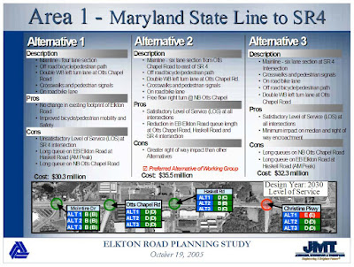
In light of recent comments, DelDOT may scale back the Elkton Road reconstruction/expansion project by nearly 2/3 to reflect actual needs. This number is derived from a reduction in added lanes between Otts Chapel Road and Route 4/896 (Christina Parkway).

Courtesy of Heather Dunigan, Wilmapco
The revision would ensure that only one additional lane will be added on the NE-bound side, to serve as an extended right turn-only lane. The SW-bound direction would maintain two through lanes similar to the existing design as we see it.

Excerpts from the Project Manager:
Based on the analysis, the alternative that could provide an effective alternative to the recommendations from the Planning study is the third option, which maintains two westbound lanes and adds a third eastbound lane from Otts Chapel Road that would end at the Route 4 intersection. With this option, the widening would be reduced in scope, but most importantly not sacrifice the needed safety improvement from Otts Chapel Road to Route 4.

We also recognize the comments that these improvements may facilitate toll evasion. Please note any roadway improvements in this part of Newark could be viewed as facilitating toll evasion; however, we feel limiting any capacity improvements to east of the Otts Chapel Road intersection should further minimize this potential issue
.

We will post again on this project after a review of the updated drawings. We have also asked DelDOT to provide us the estimated cost savings over the original proposal. In the meantime, a tip of the helmet goes to Mark Tudor of DelDOT, for responding quickly and bringing our comments and concerns before the project team. Thanks so much, Mark!

Friday, February 10, 2017

DPM: Delaware wants to lead the peloton of bike friendly states

Anthony Aglio
Delaware is currently the nation’s third most bike friendly state, according to the League of American Bicyclists. But state officials aren’t satisfied with that ranking. So Delaware’s Department of Transportation is hosting a series of public meetings in late February to find out how it can make the state even more bike friendly.   

The workshops will be opening listening sessions, according to Anthony Aglio, a bicycle planning manager for DelDOT. “We’re trying to pull people in to ask them why they aren’t bicycling, what do they like about bicycling, how can we make it better for them?” he said.

The state has also created an online survey to learn about people’s cycling priorities. “Is it safety, is it convenience, is it access to schools?” Aglio said.

DelDOT will use the input from the meetings and surveys to determine if they should be building more bike lanes, trails or safe routes to schools.

DelDOT will present a draft plan in another round of public meetings this fall. And then will use that input to craft a final plan to be released in early 2018. [Full article, including meeting details . . . ]

A lovely Sunday morning for Anthony Aglio, as he rides Route 9 en-route to Wilmington for the 2010 Delaware Bike Summit.  The Industrial Track Rail Trail, if completed, will (mostly) eliminate the need for non-motorized commuters to travel this normally congested, high speed corridor.

Thursday, February 2, 2017

Proposed Lidl in Ogletown eyed for active transportation accommodations

https://drive.google.com/open?id=0BzhSDH5rbIbdRjZTWU1oa3dQZEk
The Route 4 corridor through Ogletown has seen lots of changes over the last few decades. More recently, it was among the first chosen to receive retrofitted bike lanes/shared right turn-only lanes, helping increase safety for commuters.

In terms of land use, it was announced in September that Lidl, a German grocery chain, will be replacing Vince's Sports Center at the corner of Gender Road. The company appears committed to saving as much as 70% of the property (currently a 3-hole golf course) as open space, signing into agreement with neighboring residents. That would be an amazing goodwill gesture on the part of Lidl, given the pressure they now face with the proposed development of the Orphanage Property. In essence, it can be viewed as a re-development project that replaces an existing facility and preserves its green space.

Our Vince's-Lidl site survey has been on line for a few months, drawing 67 participants so far. The above 70% open space could be reduced to 50±% if residents get their wish for a coffee shop and/or outdoor cafe. Place-making is sorely needed in Ogletown, and many residents - even those that only drive - favor bike lane and pathway connections to nearby communities. Ange Connolly, co-admin of Save the Orphanage Property (STOP), serves on the Lidl Working Group, and presented the results in a meeting on Feb 1. In addition to place-making, she will be advocating for APBP-Standard bike parking and safe bike/ped pathway connections to Route 4 and its active transportation facilities.


As an aside, if we are to slowly but surely transform the built environment into something more bicycle and pedestrian friendly, we must have a voice in these projects early in the planning phase. And not just with new projects; advocates need to focus their energy and resources on retrofitting the suburbs. For active transportation commuters today, the construction of modern, transit-oriented developments (TODs) as an answer is way past its time. The built environment is already built, and most of our remaining open space - especially in New Castle County - is either environmentally critical or otherwise being hotly contested for parks and preservation needs.

Wednesday, February 1, 2017

Green Transportation Safety at the Glasgow Business Community

In the coming weeks, Mark Luszcz (Chief P.E, DelDOT), along with a DART Transit representative will be meeting with the Siemens Facilities Group and Dept of Environmental Health and Safety. The focus will be on bike/ped/transit improvements at the Route 896/GBC Drive intersection. Presentation below.

https://drive.google.com/open?id=0BzhSDH5rbIbdT2FIUGFSS0NrN28

The area has not been upgraded since highway construction in the mid-'90s. It was poorly designed, and left in a dangerous and undesirable condition for non-driving visitors to the Glasgow Business Community. Pedestrians are sometimes seen running across Route 896 on the north side of GBC Drive, because the existing crosswalk is on the non-building side and presents unnecessary challenges. Additionally, there are no pathway connections to and from the bus stop on the northbound side.


Further progress TBA.

Friday, January 20, 2017

DelDOT may spend millions to better accommodate I95 toll evasion

In 2005, the first public comments were gathered, and a DelDOT Working Group was assigned to select among three alternatives for the Elkton Road Reconstruction Project, Phase 2. They ultimately chose Alternative 2, the most invasive of the three, costing an additional $5M (in 2005 dollars). Among other "improvements", it includes double right turn-only lanes at Christina Parkway, and the lengthening of other dedicated turn lanes. Alternative 1, the least costly, came the closest to the original road footprint, maintaining 2 lanes in each direction.

For the record, we do not believe that bike/ped/quality of life advocates were fairly represented in this working group. All three alternatives do include a parallel pathway and bike lanes, and we are grateful for that. But we are unaware of any study data that might suggest how much of Elkton Road's current VMT (vehicle miles traveled) is the result of I95 toll evasion, and if Alternative 2 is justified.

We already know that our State Police officers are assigned to prosecuting commercial vehicles for toll evasion, using large black SUVs. It is a common sight to see, yet it is a foregone conclusion that probably most car and light truck drivers do the same to avoid paying the $4+ toll, especially if driving locally. For example, someone driving from Ogletown and points East will choose to stay on Route 4 to Elkton Road to get on I95, as opposed to using Route 896 and hitting the toll. For long haul or out of state travelers, there are even websites on how to easily circumvent.

Regardless of the toll problem, we simply can't solve congestion problems by turning our roads into a Route 13 and every intersection into a Hares Corner. Yet DelDOT is recommending a plan that will bring Elkton Road that much closer, with many more to come, and this will ultimately condemn us to 99% auto-dependency if they continue on this trajectory. Induced demand is another factor that DelDOT Planners and Engineers seriously need to consider when expanding roads and highways, but it is not clear how often they do. In the current mindset, the goal appears to be solving weight problems by adding more notches to the belt.

With this project, we may be about to spend millions of taxpayer dollars to better accommodate losing millions for our transportation coffers, which is a total travesty.

We will post further updates when we have them. In the interim, please direct your comments to Mark Tudor, Project Manager at dot-public-relations@state.de.us

http://deldot.gov/information/projects/CompletedProjects/elkton_road/pdfs/boards_workshop_10_19_05.pdf#search=Elkton%20Road%202005

http://deldot.gov/information/projects/ElktonRdMDLinetoCasho/pdfs/Workshop_Boards.pdf#search=Elkton%20Road

Thursday, January 19, 2017

Siemens Healthcare asks DelDOT to shore up commuter safety

For folks biking in the Ogletown-Glasgow area, Siemens Healthineers supports adding multi-modal safety provisions on key commuter routes. Several of their employees commute by bike, and the company recognizes the importance of reducing auto dependency.

The following letter was sent in March 2016, encouraging DelDOT to support bicycle safety and thus Green transportation alternatives. Siemens has also adopted Route 72 in the area of GBC Drive, performing annual litter patrols and cleanups. A big tip of the helmet goes to Jonathan Kroc and his Environmental Health and Safety Dept, for their wonderful stewardship on our behalf.


Note: Route 4 (Chestnut Hill Rd) has already been retrofitted with bike/shared lane treatments, and all of us hope that Route 72 (S. Chapel/Purgatory Swamp Rd) is scheduled for this year.

Wednesday, January 18, 2017

Ogletown Orphanage Property Trail Map

The Orphanage Property proposed park and trail system should be of interest to many of our readers. I mapped it by GPS last year when we first learned that it is threatened by an enormous mixed housing development. As many of you know, we are in the fight of our lives to save this beautiful landscape as a regional park for Ogletown - something that is desperately needed.

Residents in the eastern greater Newark area have been vastly underserved when it comes to parkland and open space. None of NCC's regional parks with amenities are within a safe walking or biking distance of their homes, while other surrounding areas including the City itself are continually adding them.

The easiest way to access the trail system is Pearson Drive, through Todd Estates II, south of Route 4. Pearson dead-ends at a major trail head with room for parking. Use caution; there is a small chance that you may encounter ATVs. The trails are mostly hard packed dirt, with occasional erosion and low spots that need restoration.

Please visit our facebook page dedicated to the cause, and consider liking us today!